Nemiscau
Project Location Description:
The Nemiscau property is in the James Bay region in northern Quebec, approximately 410km north of the city of Val-d’Or (Fig. 1).
Although the property would require helicopter support for access, it is only ~17 km to the east of the James Bay sealed highway and ~60km to the west of the Nemiscau airport.

Fig. 1: City of Val-d’Or
Geology
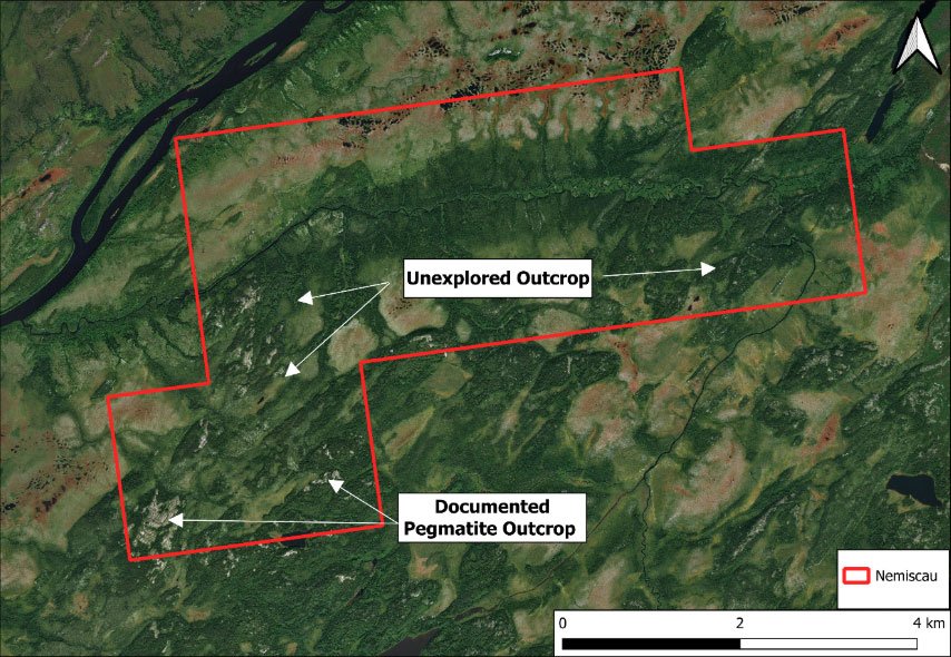
Figure 2. Satellite image of the Nemiscau property highlighting visible pegmatite outcrops.
The Nemiscau property is located in the Eastmain subprovince near James Bay in northern Quebec. Most of the property is mapped as being underlain by a rose pegmatitic granite that is in contact with a biotite-bearing granite (to the west). Key outcrop descriptions from Nemiscau are as follows:
- Outcrop 402028 is described as being pegmatite (rock code I1G) for 98% of the exposure, having a width of 10-50 meters
- Outcrop 402029 is described as being pegmatite (rock code I1G) for 98% of the exposure, also having a width of 10-50 meters
- Outcrop 402030 is described as being pegmatite (rock code I1G) for 70% of the exposure, having a width of 10-100 meters
Project Summary
The Nemiscau property is located in the James Bay region in northern Quebec (~21km to the south of the Pontax Li Deposit (10.1 Mt @ 1.04% Li2O; Cygnus Metals-Stria Lithium). The James Bay region in Quebec is host to several world-class Li pegmatite deposits and new lithium occurrences.
Combined with the presence of wide pegmatite outcrops (up to ~100m), Nemiscau is a very attractive target with confirmed wide pegmatites that warrants attention (Fig. 2). Additionally, Nemiscau is very close to infrastructure and is only ~17km from the James Bay sealed highway and ~9.5km from Hydro Quebec powerline infrastructure.
Company | Date | Work Completed | Assessment File |
Geological Survey of Quebec | 2007-2011 | Summary of magnetic surveys of James Bay | |
Geological Survey of Quebec | 2011 | Airborne magnetic survey of the southeastern part of the Nemiscau Subprovince and the northern part of the Opinaca Subprovince, James Bay, Quebec | |
Geological Survey of Quebec | 2016 | Geology of surface deposits in the Nemaska region (SNRC 32N03 northern portion, 32N06, 32N07 and 32N northern portion), Eeyou-Istchee James Bay | |
Geological Survey of Quebec | 2016 | Analyses of heavy minerals from glacial and glaciofluvial sediments in the Nemiscau region, Eeyou-Istchee James Bay | |
Geological Survey of Quebec | 2016 | Evaluation of mineral potential based on a Quaternary geological survey in the Nemaska region | |
Geological Survey of Quebec | 2016 | Geology of the Lake Nemiscau region, western sector of the Rupert River (SNRC 32N06, 32N07 and 32N11) |
Proposed Next Steps
Nemiscau will undergo a helicopter supported, reconnaissance mapping campaign in order to fully characterize the previously documented pegmatite outcrops as well as other outcrops that have not yet been mapped throughout the property. This may be supported by a property wide till sampling program in low-lying parts of the property to help delineate potential Li-mineralization that may not be observed in outcrop. If the results from the initial program are significant, a follow-up drill program may be executed based on the results of the previous mapping and till sampling programs.
Wegucci Project (Quebec)
- Location: James Bay, located along strike of Rio Tinto’s world-class Whabouchi Lithium Deposit.
- Geology: Wegucci sits on a major subprovince boundary (La Grande / Opatica), a deep-seated structure that acts as a fluid conduit for pegmatite emplacement.
- Status: Grassroots. Commissioned for reconnaissance prospecting by Laurentia Exploration in late 2025.
Proposed Next Steps
- Quebec (Wegucci & Nemiscau): Results from the Fall 2025 prospecting program (managed by Laurentia Exploration) are currently being assayed. These results will determine the follow-up mapping and stripping required for the Summer 2026 field season.